

Taal Volcano, situated on the island of Luzon in the Philippines, stands as one of the world’s most extraordinary and complex geological formations. This fascinating natural wonder has captivated scientists, tourists, and locals alike for centuries due to its unique structure and volatile history. Taal is not merely a single volcano but a complex system of craters, lakes, and islands that form a mesmerizing landscape. Its location within the Pacific Ring of Fire contributes to its high level of activity and potential for eruption. This blog post delves into the geological intricacies of Taal Volcano, exploring its formation, historical eruptions, current status, and significance in both scientific research and local culture. By examining this remarkable natural phenomenon, we gain insights into the dynamic processes shaping our planet and the delicate balance between human civilization and the powerful forces of nature.
Geological Formation and Structure
Tectonic Setting
Taal Volcano’s existence is intimately tied to the complex tectonic setting of the Philippines. The archipelago sits at the convergence of several tectonic plates, primarily the Philippine Sea Plate and the Eurasian Plate. This collision zone has given rise to numerous volcanoes along the Philippine archipelago, with Taal being one of the most prominent. The subduction of oceanic crust beneath the Philippine Mobile Belt has led to the formation of a volcanic arc, of which Taal is a part. This tectonic activity not only contributes to the volcano’s formation but also plays a crucial role in its ongoing eruptive behavior.
Volcanic Complex Structure
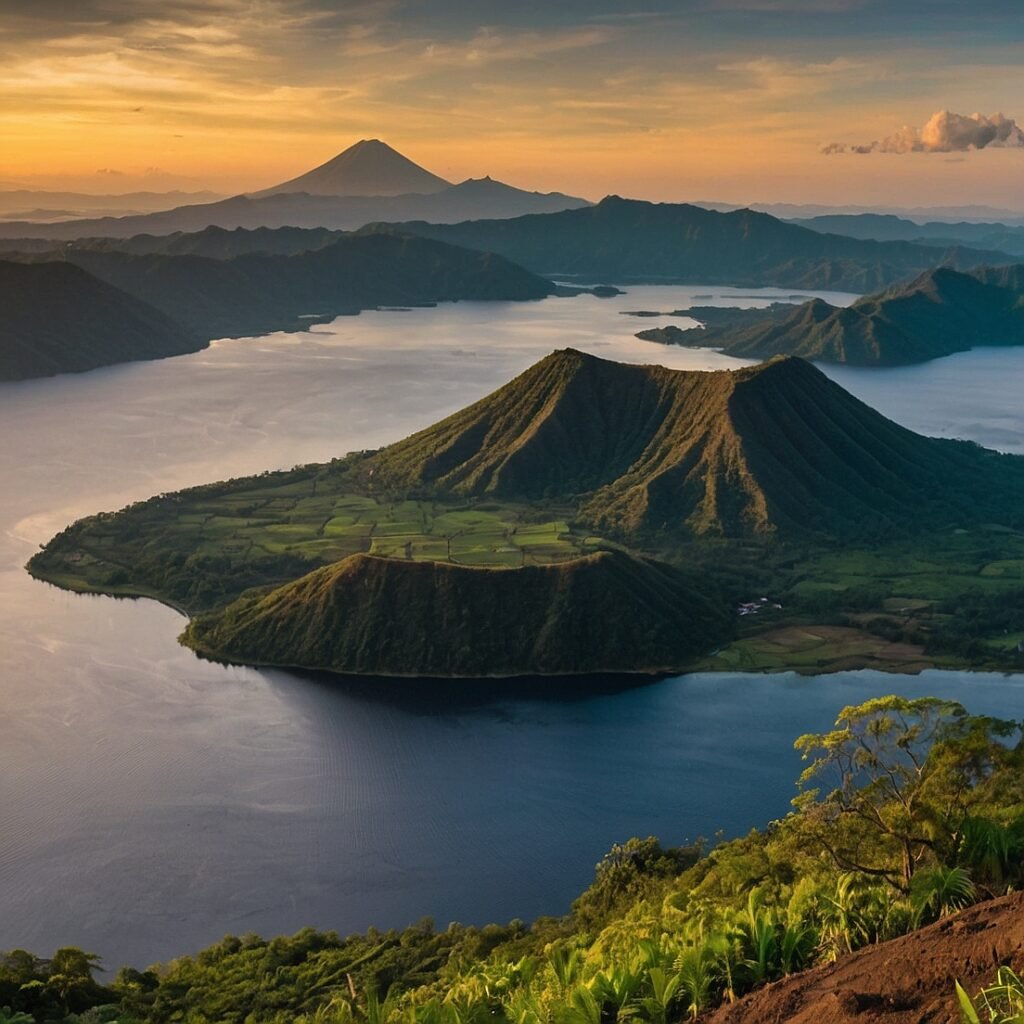
What sets Taal apart from many other volcanoes is its complex structure. It is classified as a complex volcano, which means it consists of multiple volcanic features rather than a single cone. The most striking aspect of Taal’s structure is its location within Taal Lake, which itself occupies a large caldera. This caldera, approximately 15 kilometers in diameter, was formed by prehistoric eruptions of immense magnitude. Within Taal Lake lies Volcano Island, which houses the main crater of Taal Volcano. This island within a lake within a larger caldera creates a unique “lake within a lake” phenomenon that is rare in the world.
Here’s a simplified representation of Taal Volcano’s structure:
| Feature | Description |
|---|---|
| Taal Caldera | Large caldera filled by Taal Lake, ~15 km in diameter |
| Taal Lake | Freshwater lake filling the main caldera |
| Volcano Island | Island within Taal Lake, site of the main crater |
| Main Crater | Active volcanic vent on Volcano Island |
| Crater Lake | Small lake within the main crater (when present) |
Volcanic Features
The main crater of Taal Volcano, located on Volcano Island, is a complex feature that has undergone significant changes throughout its eruptive history. It often contains a crater lake, the size and chemistry of which can fluctuate based on volcanic activity. Surrounding the main crater are numerous smaller craters, fissures, and fumaroles, all of which contribute to the volcano’s overall activity. These features serve as conduits for gases, steam, and potentially magma during eruptive episodes.
Historical Eruptions and Activity
Eruptive History Overview
Taal Volcano has a long and well-documented history of eruptions, with records dating back to the 16th century. Over the past few centuries, Taal has demonstrated a pattern of both explosive and effusive eruptions, showcasing its versatility as a volcanic system. The volcano’s eruptive style can range from relatively mild phreatic (steam-driven) explosions to more violent Plinian eruptions capable of ejecting large volumes of ash and pyroclastic material.
Here’s a timeline of some of Taal Volcano’s most significant eruptions:
| Year | Volcanic Explosivity Index (VEI) | Notable Effects |
|---|---|---|
| 1572 | Unknown | First recorded eruption |
| 1754 | 4 | Largest known historical eruption |
| 1911 | 3 | Over 1,300 fatalities |
| 1965 | 3 | Phreatomagmatic eruption |
| 1977 | 2 | Phreatic explosion |
The 1754 Eruption
The eruption of 1754 stands out as the largest known historical eruption of Taal Volcano. This event, which lasted for several months, dramatically altered the landscape of the volcano and surrounding areas. The eruption produced extensive lava flows, large-scale ashfall, and significant pyroclastic density currents. The effects of this eruption were felt over a wide area, with ash reaching as far as Manila, approximately 50 kilometers away. This event serves as a benchmark for understanding the potential magnitude of Taal’s eruptions and informs current hazard assessments.
This eruption highlighted the critical importance of volcanic monitoring and preparedness, especially given Taal’s proximity to densely populated areas.
Volcanic Monitoring and Hazard Assessment
Monitoring Technologies
Given its history of frequent eruptions and proximity to populated areas, Taal Volcano is under constant surveillance by the Philippine Institute of Volcanology and Seismology (PHIVOLCS). A comprehensive monitoring system has been established to track various indicators of volcanic activity. These monitoring efforts employ a range of technologies and methods:
- Seismic Monitoring: Networks of seismometers detect and analyze earthquake activity associated with magma movement.
- Ground Deformation Measurements: GPS stations and satellite-based InSAR (Interferometric Synthetic Aperture Radar) techniques track changes in the volcano’s shape, which can indicate magma intrusion.
- Gas Emission Monitoring: Regular measurements of gas emissions, particularly sulfur dioxide (SO2), can provide insights into magma dynamics.
- Temperature Measurements: Thermal imaging cameras and ground-based sensors monitor changes in heat output from the volcano.
- Visual Observations: Regular field observations and camera stations provide real-time visual data on the volcano’s status.
Alert Level System
PHIVOLCS employs a standardized alert level system to communicate the current status of Taal Volcano to the public and relevant authorities. This system ranges from Alert Level 0 (normal) to Alert Level 5 (hazardous eruption in progress).
| Alert Level | Description | Recommended Action |
|---|---|---|
| 0 | Normal | No alert |
| 1 | Low-level unrest | No entry into the Permanent Danger Zone |
| 2 | Increasing unrest | Additional vigilance, preparation |
| 3 | Magmatic unrest | Evacuation of high-risk areas |
| 4 | Intense unrest | Expanded evacuation |
| 5 | Hazardous eruption | Maximum alert, wide-scale evacuation |
This alert system plays a crucial role in risk communication and disaster preparedness, allowing authorities to implement timely evacuation procedures and other safety measures.
Geological and Environmental Significance
Geological Research Opportunities
Taal Volcano presents a unique laboratory for geological research, offering insights into various volcanic processes and phenomena. Its complex structure and frequent activity provide opportunities to study:
- Magma chamber dynamics and evolution
- Volcano-tectonic interactions in a subduction zone setting
- Hydrothermal systems and their influence on eruptive behavior
- Caldera formation and evolution
- Volcanic island ecosystem development
Research conducted at Taal contributes to broader understanding of volcanic systems worldwide, particularly those in similar tectonic settings.
Environmental Impact
The volcanic activity at Taal has profound effects on the surrounding environment, both during and between eruptions. These impacts include:
- Soil Fertility: Volcanic ash deposits contribute to highly fertile soils in the region, supporting agriculture.
- Lake Ecosystem: Taal Lake, formed within the caldera, hosts unique ecosystems adapted to the volcanic environment.
- Climate Effects: Major eruptions can have short-term cooling effects on regional or even global climate through ash and aerosol emissions.
- Geothermal Resources: The volcano’s heat drives geothermal systems, which have potential for sustainable energy production.
Understanding these environmental interactions is crucial for managing the region’s natural resources and assessing long-term ecological impacts of volcanic activity.
Cultural and Economic Significance
Local Culture and Mythology
Taal Volcano holds a significant place in Filipino culture, particularly for the communities living in its vicinity. Local folklore and legends often personify the volcano, attributing its eruptions to the moods or actions of supernatural beings. These cultural narratives reflect a deep-rooted relationship between the local population and the volcano, showcasing how natural phenomena become intertwined with human storytelling and belief systems.
The volcano’s presence has influenced various aspects of local culture, including:
- Traditional rituals and ceremonies related to volcanic activity
- Folk tales and legends explaining the volcano’s formation and behavior
- Artistic representations in local crafts and visual arts
This cultural significance underscores the importance of considering local knowledge and beliefs in volcanic risk management and communication strategies.
Economic Impacts
The economic implications of Taal Volcano’s presence are multifaceted, presenting both opportunities and challenges for the surrounding region:
Positive Economic Factors:
- Tourism revenue from visitors to Taal Volcano and Taal Lake
- Agricultural benefits from fertile volcanic soils
- Potential geothermal energy resources
Economic Challenges:
- Disruption to local businesses and agriculture during eruptions
- Costs associated with evacuation and relocation during volcanic crises
- Long-term infrastructure damage from ash fall and other volcanic hazards
To illustrate the economic impact, here’s a simplified breakdown of estimated costs and benefits associated with Taal Volcano (values are hypothetical for illustrative purposes):
| Economic Factor | Estimated Annual Value (USD) |
|---|---|
| Tourism Revenue | $50 million |
| Agricultural Production | $100 million |
| Geothermal Energy Potential | $30 million |
| Eruption-related Losses (averaged) | -$20 million |
| Monitoring and Preparedness Costs | -$5 million |
This balance between economic benefits and potential losses highlights the complex relationship between volcanic activity and regional economic development.
Future Outlook and Ongoing Research
Eruption Forecasting Advancements
Ongoing research at Taal Volcano focuses on improving eruption forecasting capabilities. This involves:
- Developing more sophisticated models of magma chamber dynamics
- Integrating multiple data streams (seismic, deformation, gas emissions) into comprehensive forecasting systems
- Utilizing machine learning algorithms to identify subtle precursors to eruptions
These advancements aim to provide longer lead times for warnings and more accurate assessments of eruption likelihood and potential magnitude.
Climate Change Considerations
The interplay between volcanic activity and climate change is an emerging area of research at Taal and other volcanoes worldwide. Key questions include:
- How might changing precipitation patterns affect hydrothermal systems and eruptive behavior?
- Could sea-level changes influence magma chamber pressurization in coastal and island volcanoes?
- What role do volcanic emissions play in short-term climate variability?
Understanding these interactions is crucial for long-term hazard assessment and environmental management in volcanic regions.
Sustainable Development Challenges
The presence of Taal Volcano poses unique challenges for sustainable development in the surrounding region. Ongoing research and policy development focus on:
- Balancing economic development with volcanic risk management
- Developing resilient infrastructure capable of withstanding ash fall and other volcanic hazards
- Implementing land-use policies that account for long-term volcanic risks
- Exploring innovative approaches to sustainable tourism that prioritize safety and environmental conservation
These efforts aim to create a more resilient and sustainable coexistence between human communities and the active volcanic environment.
Conclusion
Taal Volcano stands as a testament to the dynamic and powerful geological processes shaping our planet. Its complex structure, frequent activity, and profound impact on the surrounding environment and communities make it a subject of ongoing fascination and study. From its unique “lake within a lake” geography to its significant role in local culture and economy, Taal exemplifies the intricate relationships between geological phenomena and human society.
The challenges posed by Taal Volcano – from eruption forecasting to sustainable development in a volcanically active region – drive innovative research and policy development. As our understanding of this remarkable geological feature continues to evolve, so too does our ability to coexist safely with such powerful natural forces.
Taal Volcano reminds us of the ever-present dynamism of Earth’s geological systems and the need for continued vigilance, research, and preparation in the face of natural hazards. It serves not only as a natural laboratory for scientific inquiry but also as a poignant reminder of the delicate balance between the immense power of nature and the resilience of human communities.
As we look to the future, the story of Taal Volcano will undoubtedly continue to unfold, offering new insights into volcanic processes, disaster risk reduction, and the enduring relationship between humans and the geological wonders that surround us.
Disclaimer: This blog post is based on current scientific understanding and available data as of writing. Volcanic activity is inherently unpredictable, and new research may alter our understanding of Taal Volcano. Readers are encouraged to refer to official sources such as PHIVOLCS for the most up-to-date information on volcanic activity and hazard assessments. If you notice any inaccuracies in this post, please report them so we can promptly make corrections.
