

The Philippines, an archipelagic nation composed of over 7,600 islands, is a treasure trove of natural wonders that captivate the imagination and inspire awe in visitors from around the world. This Southeast Asian country, renowned for its biodiversity and stunning landscapes, boasts an array of natural marvels that have earned recognition as the Seven Wonders of Nature in the Philippines. These extraordinary sites showcase the country’s diverse ecosystems, geological formations, and unique flora and fauna. From pristine beaches and crystal-clear waters to lush rainforests and majestic mountains, the Philippines offers a glimpse into nature’s most spectacular creations. In this comprehensive exploration, we will delve into each of these seven wonders, examining their distinctive features, ecological significance, and the measures being taken to preserve them for future generations. Join us on a virtual journey through the Philippines’ most breathtaking natural attractions, as we uncover the beauty and importance of these remarkable wonders.
The Puerto Princesa Subterranean River National Park
Location and Geography
Situated on the western coast of Palawan, the Puerto Princesa Subterranean River National Park is a UNESCO World Heritage Site and one of the New7Wonders of Nature. This remarkable park spans an area of 22,202 hectares and is home to a limestone karst mountain landscape with an underground river system that flows directly into the sea. The park’s unique geology and diverse ecosystems make it a prime example of the Philippines’ natural heritage.
The Underground River
The centerpiece of the park is its underground river, which stretches for approximately 8.2 kilometers. This extraordinary waterway flows beneath a mountain range, creating a subterranean estuary where freshwater mixes with saltwater from the South China Sea. The river’s underground portion is navigable for about 4.3 kilometers, allowing visitors to explore its cavernous passages and marvel at the intricate limestone formations that adorn its walls.
Biodiversity and Ecological Significance
The Puerto Princesa Subterranean River National Park is a haven for biodiversity, supporting a wide array of plant and animal species. The park’s ecosystems range from mangrove forests to limestone karst forests, providing habitats for numerous endemic and endangered species. According to recent surveys, the park is home to:
| Category | Number of Species |
|---|---|
| Birds | 165 |
| Mammals | 30 |
| Reptiles | 19 |
| Fish | 9 |
Notable species found in the park include the Philippine cockatoo, Palawan peacock-pheasant, and the Palawan monitor lizard. The park’s rich biodiversity underscores its importance as a conservation area and ecotourism destination.
Conservation Efforts and Sustainable Tourism
To protect this natural wonder, the Philippine government, in collaboration with local communities and international organizations, has implemented various conservation measures. These include strict visitor management, waste reduction programs, and community-based ecotourism initiatives. The park’s management focuses on balancing tourism with environmental preservation, ensuring that visitors can experience its beauty while minimizing human impact on the fragile ecosystem.
The Chocolate Hills of Bohol
Geological Formation and Characteristics
The Chocolate Hills, located in the province of Bohol, are a geological phenomenon consisting of at least 1,260 perfectly cone-shaped hills spread over an area of more than 50 square kilometers. These unique formations are composed of limestone covered with grass, which turns brown during the dry season, giving the hills their distinctive chocolate-like appearance. The hills range in height from 30 to 50 meters, with the tallest reaching approximately 120 meters.
Theories on Origin
Scientists have proposed several theories to explain the formation of the Chocolate Hills:
- Marine Limestone Deposits: One theory suggests that the hills are the result of marine limestone deposits that were uplifted by tectonic activity and subsequently eroded by rainwater and groundwater over millions of years.
- Volcanic Activity: Another hypothesis proposes that the hills are remnants of ancient volcanic eruptions that were later shaped by erosion.
- Coral Reef Formation: Some researchers believe that the hills may have originated as coral reefs that were lifted above sea level and sculpted by erosion.
While the exact origin remains a subject of scientific debate, the unique landscape continues to fascinate geologists and visitors alike.
Cultural Significance and Tourism
The Chocolate Hills hold great cultural significance for the people of Bohol and have become an iconic symbol of the province. Local folklore offers various legends about the hills’ creation, often involving giants or mythical creatures. In recognition of their exceptional natural beauty and geological importance, the Chocolate Hills were declared the country’s third National Geological Monument in 1988.
Tourism to the Chocolate Hills has grown significantly in recent years, contributing to the local economy. The main viewing area in Carmen provides panoramic views of the landscape, while adventure activities such as ATV rides and zip-lining offer visitors unique ways to experience the hills.
Conservation Challenges and Initiatives
As tourism increases, conservation efforts have become increasingly important to protect the Chocolate Hills and their surrounding ecosystems. The provincial government of Bohol, in partnership with environmental organizations, has implemented measures to manage visitor impact and preserve the natural landscape. These initiatives include:
- Restricting development in the protected area
- Implementing sustainable tourism practices
- Educating visitors about the importance of conservation
- Supporting local communities in eco-friendly livelihood programs
By balancing tourism with conservation, authorities aim to ensure that future generations can continue to marvel at this extraordinary natural wonder.
The Mayon Volcano
Geographical Features and Volcanic Activity
Mayon Volcano, located in the province of Albay on the island of Luzon, is renowned for its nearly perfect symmetrical conical shape. Rising to an elevation of 2,463 meters (8,081 feet) above sea level, Mayon is an active stratovolcano that forms part of the Pacific Ring of Fire. Its picturesque silhouette has earned it the title of “the world’s most perfect cone” and made it one of the Philippines’ most recognizable natural landmarks.
Volcanic History and Recent Eruptions
Mayon Volcano has a long history of eruptions, with over 50 recorded events since 1616. Some of the most significant eruptions include:
| Year | Description |
|---|---|
| 1814 | Deadliest known eruption, causing over 1,200 fatalities |
| 1993 | Pyroclastic flows killed 75 people |
| 2006 | Eruption prompted evacuation of 40,000 residents |
| 2018 | Explosive eruption led to evacuation of over 50,000 people |
The volcano’s frequent activity has shaped the surrounding landscape and influenced local culture, with the people of Albay developing a deep respect for the mountain they call “Daragang Magayon” (Beautiful Lady).
Biodiversity and Ecosystems
Despite its volcanic activity, Mayon and its surrounding area support diverse ecosystems and wildlife. The Mayon Volcano Natural Park, established in 2000, covers an area of 5,775.7 hectares and encompasses various habitats, including:
- Lowland tropical rainforest
- Montane forest
- Grasslands and agricultural areas
The park is home to numerous plant and animal species, including several endemic to the Philippines. Conservation efforts focus on protecting these ecosystems while managing the risks associated with volcanic activity.
Tourism and Economic Impact
Mayon Volcano has become a major tourist attraction, drawing visitors from around the world to witness its majestic form and explore the surrounding region. Tourism activities include:
- Hiking and trekking (when volcanic activity permits)
- ATV tours around the volcano’s base
- Cultural tours showcasing local traditions and crafts
The volcano’s prominence has significantly boosted the local economy, providing employment opportunities in tourism-related industries and promoting the development of infrastructure in the region.
Disaster Preparedness and Risk Management
Given Mayon’s active nature, disaster preparedness is a crucial aspect of life in the surrounding communities. The Philippine Institute of Volcanology and Seismology (PHIVOLCS) closely monitors the volcano’s activity and maintains a warning system to alert residents of potential dangers. Local governments and communities have developed comprehensive evacuation plans and regularly conduct drills to ensure readiness in the event of an eruption.
The Tubbataha Reefs Natural Park
Location and Marine Protected Area Status
The Tubbataha Reefs Natural Park is a protected area of the Philippines located in the middle of the Sulu Sea. Established in 1988 and declared a UNESCO World Heritage Site in 1993, the park covers an area of 97,030 hectares and is renowned for its exceptional marine biodiversity. The park consists of two large atolls (the North and South Atolls) and the smaller Jessie Beazley Reef, forming a unique marine ecosystem that serves as a habitat for a vast array of marine life.
Marine Biodiversity and Ecological Importance
Tubbataha Reefs Natural Park is recognized as one of the most remarkable coral reefs in the world, boasting an impressive diversity of marine species. The park’s biodiversity includes:
| Category | Number of Species |
|---|---|
| Corals | 360+ |
| Fish | 600+ |
| Sharks | 13 |
| Marine Mammals | 11 |
| Seabirds | 100+ |
This rich ecosystem serves as an important breeding and feeding ground for marine species, many of which are endangered or threatened. The reefs also play a crucial role in maintaining the ecological balance of the Sulu Sea and surrounding waters.
Conservation Efforts and Management
To protect this valuable marine ecosystem, the Philippine government has implemented strict conservation measures and management strategies. These include:
- No-take zone policy: Fishing and extraction of any marine resources within the park are strictly prohibited.
- Limited tourism: Visitor numbers are carefully controlled to minimize human impact on the fragile ecosystem.
- Research and monitoring: Regular scientific studies are conducted to assess the health of the reefs and marine populations.
- Enforcement: A dedicated team of park rangers patrols the area to prevent illegal activities and ensure compliance with park regulations.
Challenges and Future Prospects
Despite its protected status, Tubbataha Reefs Natural Park faces several challenges, including:
- Climate change and coral bleaching
- Illegal fishing activities in surrounding waters
- Marine pollution and debris
- Increasing tourism pressure
Efforts to address these challenges involve collaboration between government agencies, non-governmental organizations, and local communities. Sustainable tourism practices and educational programs are being developed to raise awareness about the importance of marine conservation and the unique value of the Tubbataha Reefs.
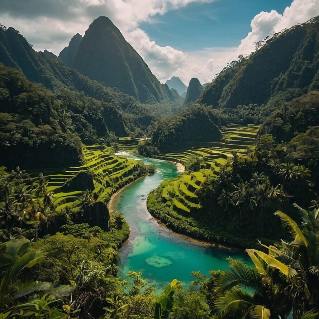
The Rice Terraces of the Philippine Cordilleras
Historical and Cultural Significance
The Rice Terraces of the Philippine Cordilleras, located in the mountainous regions of northern Luzon, are a testament to the ingenuity and agricultural expertise of the Ifugao people. These terraces, carved into the steep mountainsides over 2,000 years ago, represent a remarkable feat of engineering and sustainable land use. Recognized as a UNESCO World Heritage Site in 1995, the rice terraces are not only a marvel of ancient technology but also a living cultural landscape that continues to play a vital role in Ifugao society.
Geographical Extent and Construction
The rice terraces extend over an area of approximately 10,360 square kilometers, encompassing five clusters:
- Batad Rice Terraces
- Bangaan Rice Terraces
- Mayoyao Rice Terraces
- Hungduan Rice Terraces
- Nagacadan Rice Terraces
These terraces are built using hand-carved stone walls and an intricate irrigation system that harnesses rainwater from the mountaintops. The terrace walls, if laid end to end, would circle half the globe, showcasing the immense scale of this agricultural wonder.
Agricultural Practices and Sustainable Farming
The Ifugao people have developed a complex system of sustainable farming that has allowed them to cultivate rice in this challenging terrain for centuries. Key aspects of their agricultural practices include:
- Crop rotation and fallow periods to maintain soil fertility
- Use of indigenous rice varieties adapted to the local climate
- Traditional pest control methods that minimize environmental impact
- Communal water management systems
These practices have enabled the Ifugao to maintain a delicate balance between human needs and environmental conservation.
Challenges and Conservation Efforts
In recent years, the rice terraces have faced numerous challenges that threaten their long-term sustainability:
- Rural-to-urban migration of younger generations
- Climate change impacts, including more frequent landslides and droughts
- Changing agricultural practices and introduction of non-native species
- Increasing tourism pressure
To address these issues, various conservation initiatives have been implemented:
- Cultural heritage preservation programs
- Sustainable tourism development plans
- Agricultural support and training for local farmers
- Restoration of damaged terraces and irrigation systems
These efforts aim to ensure the continuity of this unique cultural landscape while adapting to modern challenges.
The Banaue Rice Terraces
Distinction from the Rice Terraces of the Philippine Cordilleras
While often conflated with the UNESCO World Heritage Site, the Banaue Rice Terraces are a distinct but equally impressive agricultural wonder. Located in the municipality of Banaue, Ifugao province, these terraces are sometimes referred to as the “Eighth Wonder of the World” due to their breathtaking beauty and engineering marvel. Although not officially part of the UNESCO-listed site, the Banaue Rice Terraces share many similarities with their recognized counterparts and are an integral part of the region’s cultural and agricultural heritage.
Construction and Engineering
The Banaue Rice Terraces were carved into the mountains of Ifugao over 2,000 years ago, using primitive tools and an impressive understanding of terrain and hydrology. Key features of their construction include:
- Terraces built following the natural contours of the mountains
- Stone and mud walls that can reach heights of up to 50 feet (15 meters)
- An elaborate irrigation system that distributes water from mountaintop forests
The terraces demonstrate the Ifugao people’s mastery of terrain, soil conservation, and water management, allowing them to cultivate rice in an otherwise challenging environment.
Cultural Significance and Traditional Practices
The Banaue Rice Terraces are deeply intertwined with Ifugao culture and traditions. Some notable aspects include:
- Rituals and ceremonies associated with planting and harvesting
- Traditional knowledge passed down through generations
- Communal farming practices that reinforce social bonds
- Use of indigenous rice varieties with cultural and culinary significance
These practices have helped maintain the terraces and preserve Ifugao cultural identity over centuries.
Tourism and Economic Impact
The Banaue Rice Terraces have become a major tourist attraction, drawing visitors from around the world. This influx of tourism has had both positive and negative impacts on the local community:
Positive impacts:
- Increased economic opportunities for local residents
- Greater awareness of Ifugao culture and heritage
- Funding for conservation and infrastructure improvements
Negative impacts:
- Pressure on traditional agricultural practices
- Potential overexploitation of natural resources
- Cultural commodification
Balancing tourism development with cultural and environmental preservation remains a key challenge for local authorities and communities.
Conservation Challenges and Initiatives
Like other rice terraces in the region, Banaue faces several conservation challenges:
- Erosion and degradation of terrace walls
- Changing climate patterns affecting water supply
- Abandonment of terraces due to rural-to-urban migration
- Introduction of non-native plant species
To address these issues, various initiatives have been implemented:
- Terrace restoration projects involving local communities
- Educational programs to encourage younger generations to continue farming
- Promotion of sustainable tourism practices
- Research on climate-resilient agricultural techniques
These efforts aim to ensure the long-term sustainability of the Banaue Rice Terraces while preserving their cultural and ecological significance.
The Taal Volcano
Geographical Features and Volcanic Complexity
Taal Volcano, located in the province of Batangas on the island of Luzon, is one of the Philippines’ most active and complex volcanoes. It is situated within a larger caldera formed by prehistoric eruptions, creating a unique landscape where a lake (Taal Lake) surrounds the active volcanic island. The main volcanic island, Volcano Island, contains the primary crater lake, which itself has hosted eruptions, making Taal a remarkable example of a “lake within a lake within a lake.”
Key Features of Taal Volcano:
- Total area of Taal Lake: Approximately 234.2 square kilometers
- Elevation of the main crater rim: 311 meters (1,020 feet) above sea level
- Number of craters/cones: 47 (including the main crater)
Volcanic History and Recent Activity
Taal Volcano has a long history of eruptions, with 34 recorded eruptions since 1572. Some of the most significant events include:
| Year | Description |
|---|---|
| 1754 | Largest historical eruption, lasting 7 months |
| 1911 | Violent eruption causing over 1,300 fatalities |
| 1965 | Eruption led to the formation of a new island |
| 2020 | Phreatomagmatic eruption caused widespread evacuation |
The 2020 eruption, in particular, highlighted the ongoing volcanic risk and the need for continued monitoring and disaster preparedness in the region.
Ecological Significance and Biodiversity
Despite its volcanic activity, Taal and its surrounding area support a unique ecosystem. The Taal Volcano Protected Landscape, established in 1996, covers an area of 62,292 hectares and includes both terrestrial and aquatic habitats. Some key ecological features include:
- Endemic species: The Taal Volcano complex is home to several endemic species, including the Taal Volcano strain of the freshwater sardine (Sardinella tawilis).
- Diverse habitats: The area encompasses various ecosystems, from the volcanic island to the surrounding lake and nearby forests.
- Importance for migratory birds: Taal Lake serves as a stopover for many migratory bird species.
Tourism and Local Economy
Taal Volcano has become a popular tourist destination due to its proximity to Manila and its striking landscape. Tourism activities include:
- Boat trips to Volcano Island
- Hiking to the crater lake (when conditions permit)
- Viewing points around Taal Lake
- Cultural tours of nearby towns
The volcano’s prominence has significantly impacted the local economy, providing employment opportunities in tourism-related industries and promoting the development of infrastructure in the surrounding areas.
Volcanic Hazard Management and Community Preparedness
Given Taal’s active nature and its proximity to populated areas, volcanic hazard management is crucial. Key aspects of the management strategy include:
- Continuous monitoring: The Philippine Institute of Volcanology and Seismology (PHIVOLCS) maintains a network of sensors to detect volcanic activity.
- Alert level system: A standardized alert level system informs the public and local authorities about the volcano’s status.
- Evacuation plans: Comprehensive evacuation plans have been developed for communities around the volcano.
- Public education: Regular drills and information campaigns help residents prepare for potential eruptions.
These measures aim to minimize the risk to human life and property in the event of future volcanic activity.
Conclusion
The Seven Wonders of Nature in the Philippines showcase the country’s remarkable biodiversity, geological marvels, and cultural heritage. From the underground river of Puerto Princesa to the iconic cone of Mayon Volcano, each wonder offers a unique glimpse into the natural beauty and ecological significance of the Philippine archipelago. These sites not only serve as popular tourist destinations but also play crucial roles in biodiversity conservation, scientific research, and cultural preservation.
As we have explored, each of these wonders faces its own set of challenges, ranging from the impacts of climate change to the pressures of increasing tourism. However, through concerted conservation efforts, sustainable management practices, and community involvement, steps are being taken to protect these natural treasures for future generations.
The Philippines’ Seven Wonders of Nature stand as testaments to the country’s rich natural heritage and the importance of preserving our planet’s most extraordinary landscapes. They remind us of the delicate balance between human activity and environmental conservation, and the need for responsible stewardship of our natural world. As we continue to marvel at these wonders, let us also commit to their protection, ensuring that they remain sources of inspiration, learning, and natural beauty for years to come.
Disclaimer: This article is based on the most current information available at the time of writing. Natural wonders are subject to change due to geological processes, climate factors, and human activities. While every effort has been made to ensure accuracy, readers are encouraged to consult the latest official sources for the most up-to-date information on these sites. If you notice any inaccuracies, please report them so we can promptly make corrections.
