
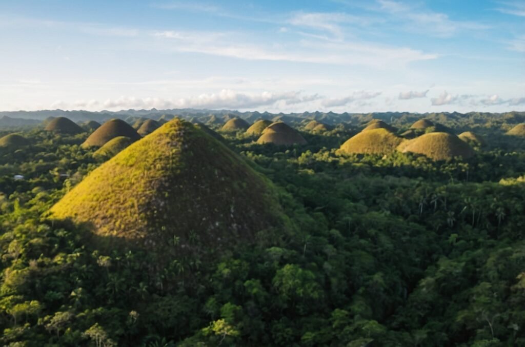


The Chocolate Hills of Bohol, Philippines, stand as one of nature’s most captivating geological wonders. These unique formations, numbering over 1,200 nearly symmetrical mounds, have captivated tourists and scientists alike for generations. Spread across an area of more than 50 square kilometers, these hills range from 30 to 50 meters in height, creating a surreal landscape that has become synonymous with the island province of Bohol. This natural phenomenon, declared the country’s third National Geological Monument in 1988, continues to intrigue visitors with its peculiar appearance and the mysteries surrounding its formation. In this comprehensive exploration, we will delve into the geological processes that shaped these remarkable hills, examine the local legends that have grown around them, and discuss their significance to both the scientific community and the cultural heritage of the Philippines.
Geological Formation of the Chocolate Hills
The Karst Topography Theory
The prevailing scientific explanation for the formation of the Chocolate Hills involves a geological process known as karst topography. This process occurs in landscapes composed primarily of soluble rocks such as limestone, dolomite, and gypsum. In the case of the Chocolate Hills, the underlying bedrock is predominantly limestone, a sedimentary rock formed from the accumulation of marine organisms over millions of years.
The formation of these hills is believed to have occurred through the following stages:
- Marine Sedimentation: Approximately 2 million years ago, during the Pliocene epoch, the area that is now Bohol was submerged beneath a shallow sea. Over time, marine organisms like corals and mollusks deposited their calcium-rich remains on the seafloor.
- Uplift and Exposure: Tectonic activity caused the seafloor to rise, exposing the limestone deposits to the air and forming a vast limestone plateau.
- Erosion and Weathering: Once exposed, the limestone underwent extensive weathering and erosion. Rainwater, which is slightly acidic due to dissolved carbon dioxide, gradually dissolved the limestone, creating a karst landscape characterized by sinkholes, caves, and underground drainage systems.
- Differential Erosion: The hills we see today are the more resistant remnants of this erosion process. The spaces between the hills were eroded more quickly, leaving behind the conical or dome-shaped mounds.
Alternative Theories
While the karst topography theory is widely accepted, other hypotheses have been proposed to explain the unique formation of the Chocolate Hills:
- Volcanic Activity: Some early theories suggested that the hills might be extinct volcanoes. However, this has been largely discredited due to the lack of volcanic materials in the area.
- Tectonic Uplift: Another theory proposes that tectonic forces pushed up sections of the limestone plateau, creating the hills. While tectonic activity played a role in exposing the limestone, it is not considered the primary mechanism for shaping the hills.
- Ancient Coral Reefs: A variation of the karst theory suggests that the hills may have originated as ancient coral reefs that were later exposed and eroded.
To illustrate the geological composition of the Chocolate Hills, here’s a simplified stratigraphic column:
| Layer | Composition | Approximate Age |
|---|---|---|
| Top Soil | Clay-rich residual soil | Recent |
| Weathered Limestone | Highly weathered limestone | Pleistocene |
| Compact Limestone | Dense, less weathered limestone | Late Pliocene – Early Pleistocene |
| Maribojoc Limestone | Marine sedimentary limestone | Early – Middle Pliocene |
| Basement Rock | Metamorphic or igneous bedrock | Pre-Tertiary |
The Unique Appearance of the Chocolate Hills
Distinctive Features
The Chocolate Hills are renowned for their near-perfect conical or dome shape and their relatively uniform size and distribution. These characteristics contribute to their otherworldly appearance and have made them a subject of fascination for geologists and tourists alike.
Key features of the Chocolate Hills include:
- Shape: Conical or dome-shaped mounds
- Height: Typically ranging from 30 to 50 meters, with the tallest reaching about 120 meters
- Number: Estimates range from 1,260 to 1,776 hills
- Distribution: Spread across an area of more than 50 square kilometers
- Composition: Primarily composed of limestone covered with grass
Seasonal Color Changes
The name “Chocolate Hills” derives from the brown color the mounds take on during the dry season, typically from late November to May. During this period, the grass covering the hills dries out, giving them a chocolate-like hue. In contrast, during the rainy season, the hills are covered in lush green vegetation, presenting a dramatically different landscape.
This seasonal transformation can be visualized in the following chart:
Month    | J | F | M | A | M | J | J | A | S | O | N | D |
Color    | B | B | B | B | B | G | G | G | G | G | B | B |

Legend: B = Brown, G = Green
Local Legends and Cultural Significance
Mythological Origins
The Chocolate Hills have been woven into the fabric of local folklore, with several legends attempting to explain their mysterious origins. These stories reflect the rich cultural heritage of the region and demonstrate the deep connection between the people of Bohol and their unique landscape.
Some of the most popular legends include:
- The Battle of the Giants: This tale recounts a fierce battle between two giants who hurled boulders, rocks, and sand at each other for days. When they finally exhausted themselves and made peace, they left behind the mounds of earth that became the Chocolate Hills.
- Tears of a Heartbroken Giant: Another legend tells of a giant named Arogo who fell in love with a mortal woman. When she died, the giant wept, and his tears turned into hills as they dried.
- The Carabao’s Droppings: A more humorous tale suggests that the hills are the droppings of a giant carabao (water buffalo) that once roamed the island.
- The Curse of Dano: This legend speaks of a young man named Dano who stole from his neighbors. As punishment, the gods showered the land with small hills, forcing Dano to return everything he had stolen before the hills would stop growing.
These legends, while fanciful, serve an important cultural purpose. They provide a connection to the land, offer explanations for natural phenomena in the absence of scientific knowledge, and serve as vehicles for moral lessons and community values.
Cultural and Economic Importance
The Chocolate Hills have become an integral part of Bohol’s identity and economy. Their significance extends beyond mere geological interest:
- Tourism: The hills are a major tourist attraction, drawing visitors from around the world and contributing significantly to the local economy.
- National Symbol: They appear on the provincial flag and seal of Bohol, symbolizing the unique identity of the region.
- Conservation: The hills’ status as a protected geological monument has raised awareness about environmental conservation in the area.
- Scientific Research: The unique formation continues to attract scientific interest, contributing to our understanding of karst landscapes and geological processes.
Scientific Studies and Conservation Efforts
Geological Research
The Chocolate Hills have been the subject of numerous scientific studies aimed at understanding their formation and geological significance. Some key areas of research include:
- Karst Evolution: Studies on the development of karst landscapes and the specific processes that led to the formation of the Chocolate Hills.
- Paleoclimate Analysis: Examination of the limestone composition to gain insights into past climate conditions.
- Geomorphological Mapping: Detailed mapping of the hills to understand their distribution and structural patterns.
- Soil Analysis: Studies on the composition and properties of the soil covering the hills.
Conservation Challenges
Despite their protected status, the Chocolate Hills face several conservation challenges:
- Erosion: Natural weathering processes continue to shape the hills, potentially altering their iconic appearance over time.
- Human Impact: Increased tourism and development in the surrounding areas pose risks to the natural environment.
- Climate Change: Shifting weather patterns may affect the vegetation cover and erosion rates of the hills.
To address these challenges, various conservation efforts have been implemented:
| Conservation Measure | Description | Implementing Body |
|---|---|---|
| Legal Protection | Declaration as a National Geological Monument | Philippine Government |
| Tourism Management | Controlled access and designated viewing areas | Local Tourism Office |
| Reforestation | Planting of native species in surrounding areas | Department of Environment and Natural Resources |
| Research Programs | Ongoing scientific studies to inform conservation strategies | Universities and Research Institutions |
| Community Education | Programs to raise awareness about the hills’ importance | Local NGOs and Schools |
The Chocolate Hills in the Global Context
Comparison with Similar Formations
While unique, the Chocolate Hills share some characteristics with other karst landscapes around the world. Some comparable formations include:
- The Stone Forest (Shilin) in Yunnan, China
- Tsingy de Bemaraha in Madagascar
- The Pinnacles in Gunung Mulu National Park, Malaysia
- Torre del Paine in Chile
Each of these landscapes showcases the diverse ways in which karst topography can manifest, depending on local geological conditions and climate.
Global Recognition
The Chocolate Hills have gained international recognition for their distinctive appearance and geological significance:
- UNESCO World Heritage Site Nomination: Efforts have been made to have the Chocolate Hills listed as a UNESCO World Heritage Site, which would further elevate their global status and protection.
- Scientific Interest: The hills continue to attract researchers from around the world, contributing to the global understanding of karst landscapes.
- Tourism Impact: As an international tourist destination, the Chocolate Hills play a role in cultural exchange and global awareness of Philippine natural wonders.
Future Prospects and Challenges
Sustainable Tourism Development
As tourism continues to grow, balancing economic development with conservation becomes increasingly crucial. Future plans for the area may include:
- Sustainable infrastructure development
- Eco-friendly accommodation options
- Educational programs for visitors
Climate Change Impacts
The potential effects of climate change on the Chocolate Hills are a growing concern. Possible impacts include:
- Altered vegetation patterns
- Increased erosion due to extreme weather events
- Changes in the seasonal color transitions
Research Opportunities
Future research directions may focus on:
- Long-term monitoring of the hills’ shape and composition
- Advanced geological dating techniques to refine the formation timeline
- Interdisciplinary studies combining geology, ecology, and cultural heritage
Conclusion
The Chocolate Hills of Bohol stand as a testament to the incredible diversity of our planet’s landscapes. Their formation, shrouded in both scientific inquiry and local legend, continues to captivate the imagination of visitors and researchers alike. As we move forward, the challenge lies in preserving this natural wonder while allowing for responsible exploration and study. The hills not only represent a unique geological phenomenon but also embody the cultural heritage of the Philippines, serving as a bridge between scientific understanding and folkloric tradition. By continuing to study, protect, and appreciate the Chocolate Hills, we ensure that future generations can marvel at this extraordinary landscape, just as we do today.
Disclaimer: While every effort has been made to ensure the accuracy of the information presented in this article, geological sciences and local cultural interpretations can evolve. Readers are encouraged to consult current scientific literature and local authorities for the most up-to-date information. If you notice any inaccuracies, please report them so we can promptly make necessary corrections.
